Thank you for your patience while we retrieve your images.
Taken 16-May-11
5 of 17 photos


Upper Antelope Canyon, Narrows to Chambr

Upper Antelope Canyon is located on Navajo land near Page, Arizona within the LeChee Chapter of the Navajo Nation. Antelope Canyon includes two separate, slot canyon sections – one on either side of Route AZ98 a few miles East of Page. These canyons are referred to individually as Upper Antelope Canyon or The Crack; and Lower Antelope Canyon or The Corkscrew.

The Navajo name for Upper Antelope Canyon is Tsé bighánílíní, which means "the place where water runs through rocks" and water is what created the canyons as it flowed through and eroded the Navajo Sandstone. This primarily happens during flash flooding. Rainwater, especially during monsoon season, runs into the extensive basin above the slot canyon sections, picking up speed and sand as it rushes into the narrow passageways. Over time the passageways are eroded away, making the corridors deeper and smoothing hard edges in such a way as to form characteristic 'flowing' shapes in the rock.

Flooding in the canyon still occurs. A flood occurred on October 30, 2006 that lasted 36 hours, and caused the Tribal Park Authorities to close Lower Antelope Canyon for five months.

Capture Date=5/16/2011
Folder Name=2011-05c - Page Slot Canyons
File Name=7d001-#6432
Exposure=1/15 sec at f/5.6 ISO 500
Lens=EF16-35mm f/2.8L USM at 16 mm
Canon EOS 7D, f/5.6 @ 16 mm, 1/15, ISO 500, No Flash

Categories & Keywords
Category:
Subcategory:
Subcategory Detail:
Keywords:Arizona, Dan Hartford Photo, Desert Area, Erosion Sculpture, Landscape, Navajo Nation, North America, Page Area, Rock Formation, Slot Canyon, Southwest States, Tribal Park, USA, United States, Upper Antelope Canyon, CaptureDate=5/16/2011, FolderName=2011-05c - Page Slot Canyons, FileName=7d001-#6432

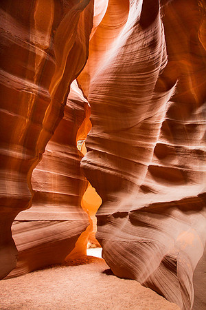
Upper Antelope Canyon, Narrows to Chambr